


Passage Plan
Northport is navigable through a completely buoyed and lit channel 5 nautical miles long leading from the Fairway Buoy to Marsden Point. The approach to Marsden Point has a shallowest depth of 14.7m at chart datum between the Fairway Buoy and No 1 buoy.
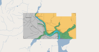
Whangarei Harbour
scale: 1:18000
File reference: NZ521501.tif
Data published and maintained by the New Zealand Hydrographic Authority at Land Information New Zealand (LINZ).
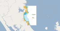
Approaches Marsden Point
scale: 1:50000
File reference: NZ521901.tif
Data published and maintained by the New Zealand Hydrographic Authority at Land Information New Zealand (LINZ).
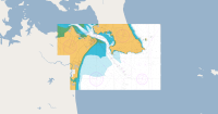
Marsden Point
scale: 1:18000
File reference: NZ521401.tif
Data published and maintained by the New Zealand Hydrographic Authority at Land Information New Zealand (LINZ).

Distance To / From
The chart identifies the distances to and from Northport, Marsden Point and all other New Zealand ports. All distances are in nautical miles (nm)